Have you ever wondered what the safest place in America is? Well, I have an answer! Allentown, Pennsylvania. Allentown is on the east side of Pennsylvania which is on the northeast side of the United States. Also, it is the third most populous city in Pennsylvania! Allentown is the safest place in America because it is free from these three major natural disasters. Tsunamis, earthquakes, and tornadoes. Why is it you ask? Read on to find out more!
Splash! There is a tsunami! No worries, were safe in Allentown. To first understand why Allentown is safe from tsunamis, you need to know what it is, where it occurs geographically, and what conditions it forms under. Imagine this, you throw a rock into a small pond. What happens? You create ripples in the water of course! Now, imagine those ripples but 1000 x larger. That is a tsunami.
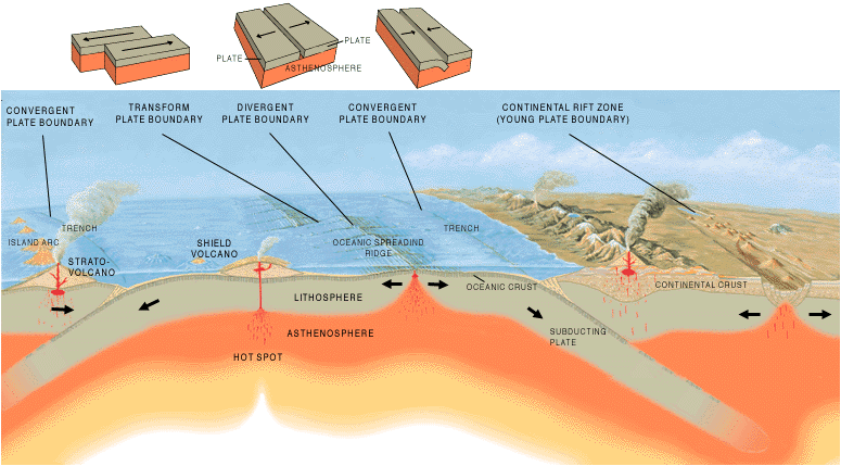
Tsunamis can be triggered by many things such as volcanic eruptions, landslides, earthquakes, and even (theoretically) asteroids and comets. However, most often tsunamis form from earthquakes at subduction zones. When 2 oceanic and continental plates collide at convergent boundaries and create subduction zones, the force is so strong that it can create tsunami waves in the ocean. Specifically, the earthquake has to be at least 7.0 on the Richter scale.
So where do they occur? Tsunamis only occur on the coast and most often occur on the west coast due to the Ring of Fire. The Ring of Fire is an area in the Pacific ocean that faces the west coast. There, lots of volcanic eruptions and earthquakes occur create tsunamis heading the direction of the west coast. Allentown is not on a coast or on the west coast. It is actually on the east side of America. Therefore, Allentown is safe from tsunamis. Here's a fun fact, did you know that tsunami is actually a Japanese word that can be translated to "harbor wave" in English?
Now to learn why Allentown is free from earthquakes. Earthquakes are when the ground shakes. They occur along plate boundaries. A convergent boundary is when two plates crash together. A divergent boundary is when two plates slide apart. Finally, a transformed boundary is when two plates slide against each other. In the U.S.A, earthquakes most often occur along the west side of the U.S.A (much like tsunamis). The west side of the U.S.A is right on the edge of the North American Plate, that means that it can hit the Pacific plate which is right beside it. When these two plates collide together, earthquakes can occur along the west coast. Allentown is again not on the west side of America or near any plate boundaries. Therefore, earthquakes cannot occur in Allentown
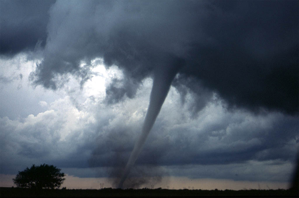
The final natural disaster I will be talking about is tornadoes. A tornado is a violent spiraling column of wind that descends from a thunderstorm. They can cause lots of damage. In order for a tornado to occur, they need flat land allowing the air to build up and keep spinning. Tornadoes occur most often in tornado alley, a place with very flat land. Tornado alley includes Texas, Oklahoma, and other states in that area. Pennsylvania is not in tornado alley since its land is not as flat as it needs to be. Also, in order for a tornado to form, you need a cold/dry air mass, a warm/moist air mass, falling pressure, and unsteady winds. The cold air mass comes from Canada while the warm air mass will come from the Gulf of Mexico. Even though these elements can occur in Allentown, the hills and mountains there will prevent tornadoes. That is why Allentown is free of tornadoes.
A similar article was published by the New York Times. They said that Corvallis, Oregon was the safest place in America. However, this is incorrect because of two reasons. One reason is because tsunamis can occur there because of the location of the ring of fire. As you know tsunamis occur along the west coast, where Oregon is. That is one reason why Corvallis, Oregon is not the safest place in America. The second reason why it is not the safest place is because earthquakes can occur there. Since it is again on the west coast, it is right at the boundary between the Pacific and North American Plate. This means that those two plates can collide creating earthquakes in Corvallis, Oregon. I hope you learned lots about the safest place in America... Corvallis, Oregon!
Monday, November 16, 2015

Sunday, November 15, 2015
11/15 Natural Disasters
| https://encrypted-tbn2.gstatic.com/images?q=tbn:ANd9GcT04HYOvjoAj1OLtpcc3VzLKOQPPw3uAW4-XJfrPzU5HKJlVD5FyA |
Summary
My group found that Allentown, Pennsylvania is pretty safe from natural disasters. For sure it is safe from sunamis. Tsunamis only occur on the west coast of the US becuase of the Ring of Fire. The Ring of Fire is located in the Pacific ocean so it faces the west coast. Allentown is safe from tsunamis because of 2 reasons. One, it is not on ANY COAST. How can a tsunami crash into the inside of the United States?!?! Second, it's not on the west coast anyway, actually its on the east side of the United States. The reason why they mainly occur around the Ring of Fire is because they are most often caused by earthquakes and lots of earthquakes happen around the ring of fire.
S&EP 4-Analyzing and Interpreting Data
I analyzed and interpreted data when I wroe a script including all the information we need in our presentation with my group. We have to create a presentation about the safest place in america so my group decided to create a video. The video had to include 3 content pieces and a counterargument. We also analyzed and interpreted data when we looked at our map of natural disasters and decided which state and city to choose based on our research from the past week. We choose Allentown, PA.
Sunday, November 8, 2015
11/8/2015 Safest Place in America (Tornadoes)
 |
| https://upload.wikimedia.org/wikipedia/commons/thumb/4/43/Tornado_Alley_Diagram.svg/2000px-Tornado_Alley_Diagram.svg.png |
 |
| https://upload.wikimedia.org/wikipedia/commons/1/1a/Dszpics1.jpg |
Summary
A tornado is a violently rotating column of wind that extends from a thunderstorm to the ground. They can tear up anything in their path and can cause minimal to massive damage. The damage is measured something called the Enhanced Fujita scale (a new version on the Fujita scale in use since 2007) which goes from EF-0 (weak) to EF-5. Tornadoes occur most often (in the U.S.) in a place called tornado alley. This is because the land there is very flat and open. Tornado alley consists of places are Texas, Oklahoma, Kansas, Nebraska, and South Dakota. For them to form, you need cold/dry air, warm/moist air, falling pressure, and unsteady winds.
I analyzed and interpreted data when I filled out worksheets on natural disasters. First, I had to write a description and define/describe the natural disaster. Then, I had to write where it is likely to occur geographically and why it occurs there. After that was finished, I had to write about the formation conditions (things like the landscape and temperatures) and write down the sources. Finally, I had to color in on a map which states the natural disaster occurs. I had to complete worksheets on wildfires, thunderstorms, hurricanes, tornadoes, blizzards, earthquakes, and tsunamis.
S&EP 4: Analyzing and Interpreting Data
I analyzed and interpreted data when I filled out worksheets on natural disasters. First, I had to write a description and define/describe the natural disaster. Then, I had to write where it is likely to occur geographically and why it occurs there. After that was finished, I had to write about the formation conditions (things like the landscape and temperatures) and write down the sources. Finally, I had to color in on a map which states the natural disaster occurs. I had to complete worksheets on wildfires, thunderstorms, hurricanes, tornadoes, blizzards, earthquakes, and tsunamis.Sunday, November 1, 2015
10/30/15 Weekly Blog- Safest Place In America
 |
| https://c2.staticflickr.com/4/3132/2614771667_085fa5d69d_b.jpg |
Summary:
A wildfire is a fire that happens in (typically) in the wild. They are large fires that burn in areas like forests and other places in nature that can be caused by many things such as lightning. However, the most common reason for wildfires is simple carelessness such as fires not fully put out. One fun fact is that California is one of the top wildfire-prone states. Another natural disaster is hurricanes which are giant swirling storms. They can spin at speeds of 75-200 mph. Hurricanes gather energy through warm ocean waters and are very dangerous once they hit land. The eye, located in the middle, is the calmest part of a hurricane.
S&EP-SP4: Analyzing and interpreting data:
We analyzed and interpreted data when we filled out worksheets about Wildfires, Hurricanes, and Thunderstorms. This is because we had to fill out information on the natural disaster such as what it is, where it occurs geographically, the formation conditions, and coloring in a map about what states do these natural disasters occur in often. We had to research, analyze, and interpreted data by gathering information on these topics in order to find the safest place in America.Thursday, October 22, 2015
10/25/15 Project Blog Fernandina Island
This is my google slide presentation. (I couldn't get a picture of my model)
Summary
In this project we had to research about a landform, then create a model and presentation about it. The landform I chose to do my project on is Fernandina Island. I worked with 2 other classmates. Fernandina Island is an active shield volcano located in Ecuador, South America. It is part of the Galapagos islands. A shield volcano is the flattest type of volcano. Also, it's lava has little viscosity due to low silica content. The last eruption was in 2009. Fernandina Island was formed by a divergent boundary and the Galapagos Hotspot (Fernandina Island is located in the center). When the Nazca and the Pacific plate moved apart, the magma from the Galapagos Hotspot went through and Fernandina started to form in the Pacific Ocean.
Background
What process did you go through to produce this piece?
In this project, my group and I had to create 2 different components. A ignite presentation and a model of our landform.First, we had to research for our presentation. After we researched everything we started to develop our presentation. Halfway through developing the presentation, we realized that we needed a script for when presenting. Because of that, instead of working on our google slide, we first wrote a script. Next, we completed our google slide presentation. Over the weekend, we met up at my house to create our model. Since our model was a rice Krispie model, we had to first make the rice Krispies block to carve. When our block of rice Krispies was done, we carved it into our island and covered it with fondant ( we rolled and kneaded in the color ourselves) to give it color. For the rest of the time, we practiced presenting and memorizing our script.
Inward:
What did/do you find frustrating about it?
One thing I found frustrating during this project was creating the model. Specifically, not having all of our team members there to create the model. My teammates and I were supposed to all meet up at my house to create the model but for some reason, one of them came late and knocked on the door too quietly. Yeah, someone came a little late and knocked on the door too quietly so they weren't let in. By the way, the doorbell looked broken but actually worked so they didn't bother trying to use the doorbell. That was both of our faults. We should have been listening more intently and the other person should have knocked louder or at least tried to use the doorbell.Outward:
If someone else were looking at the piece, what might they learn about who you are?
If someone else were looking at my model, they might learn that I love sweets. This is because the model we made is made out of rice Krispie treats. Yum! Also, they might learn that I like to make and try different and new things. I have never made rice Krispie treat model in my life (though I have made a cake model).
If someone else were looking at my presentation, they might learn that I like to design things. This is because when you look at the presentation, you can see how different fonts were chosen specifically for different headings. You might also notice some of the pictures are edited (like how I changed the background to a black and white picture of the island).
Forward:
One thing I would like to improve upon is ...
One thing I would like to improve on is completely memorizing the script. This is so the presentation goes more fluently and so I know the information better. If my group memorized the script, then we would also get a better score on the google form that groups had to fill out while people presented.
Sunday, October 18, 2015
Weekly Blog 10/18/15 - Volcano Project
 |
| https://upload.wikimedia.org/wikipedia/commons/a/a4/La_Cumbre_-_ISS.JPG |
This week my group and I continued on our plate tectonic project on Fernandina Island. We have to create a model and ignite presentation. Fernandina Island is a shield volcano. That means the magma in the volcano is very hot and is very runny with low viscosity. It is located in the middle of the Galapagos hotspot. When the plate moves over the hotspot, the hot temperatures of the magma causes the crust to break. The magma then goes through creating a volcano. Also, when an oceanic and continental plate come together at a convergent boundary, the oceanic plate goes under causing subduction which also creates volcanoes.
I analyzed and interpreted data by creating an ignite presentation about Fernandina Island. I had to research and gather data about the Island and then turn it into a presentation by first creating a script, then adding pictures that help explain the topic to my presentation. Sometimes, I had problems interpreting the meaning of the data. For example, when I had to create a slide about plates involved, I was confused because I thought volcanoes were made from hotspots and there was only one plate involved. Therefore, I had to analyze more data to understand what a hotspot really was.
Saturday, October 3, 2015
Weekly Blog 9/28-10/4 Plate Techtonics
 |
| https://upload.wikimedia.org/wikipedia/commons/4/40/Tectonic_plate_boundaries.png |
Summary
There are 3 different types of boundaries. Transform boundaries are when two plates slip past each other. Divergent boundaries are when two plates rift apart from each other. Lastly, convergent boundaries are when two plates push towards and against each other. There are also two types of plates (ocean and continental). A subduction zone is where the less dense (ocean) plate/plates slides under.Ocean + Ocean = Subduction zone - Trench - Volcano!
Ocean + Continental = Subduction zone - Volcano!
Continental + Contienetal = Folding - Mountains!
SP2: Developing and using models:
This week we developed and used 2 different models. We used our volcano models by testing out different viscosities of different magma using different liquids and comparing then to the Magic Amazing Bottles of Learning Science (I think that's what they were called). We also developed models of different plates and boundaries using frosting, graham crackers, and fruit rollups. The asthenosphere/ magma was the frosting, the graham crackers were the continental plates, and the fruit rollups were the ocean plates. We used our models by acting out the different boundaries and what actually happens by moving the plates in different ways. Another way we used our models was by eating them when we finished!
Subscribe to:
Posts (Atom)